
Block Management in St Austell
Several neighbourhood plans at the edges and none at all over the town core.
From our Plymouth office, about 40 road miles away, we provide block, estate and leasehold management to St Austell RMCs, RTM companies and freeholders. All 24 one-kilometre squares over the town are class 6, the top radon band, with measurement advised. The town has no contained Environment Agency flood area, and no neighbourhood plan covers the parish that holds 81.7 per cent of it.
What We Would Put First for a Block in St Austell
Commission Communal Radon Measurement
Every square over the built-up area reads class 6, where more than 30 per cent of homes are estimated to reach the action level and measurement is advised. We would commission radon measurement in the communal areas of each block and log the results.
ComplianceMap Which Plan Applies at the Edge
St Austell parish has no neighbourhood plan, but plans for St Mewan, St Austell Bay and Carlyon cover the fringes. We would confirm which policies apply to the block before preparing alteration consents or works.
ConsentsInsure on Position, Not Area Labels
The St Austell and Par Rivers alert carries the town's name but names Pentewan, St Blazey, Luxulyan and Mevagissey instead, and no Environment Agency area names a single St Austell street. We would present the block's actual position to insurers.
InsuranceInspect Charlestown Blocks Separately
The town centre is about two miles inland of St Austell Bay, and exposure differs markedly for the Charlestown and Porthpean stock, where Charlestown also has an Article 4(2) direction. We would set inspection scope for those blocks accordingly.
InspectionsManaging a Block in St Austell at a Glance
- Local authority
- Cornwall Council
- Authority type
- Unitary
- Building control
- Cornwall Council Building Control
- County
- Cornwall
- Fire and rescue service
- Cornwall Fire and Rescue Service
- Water and sewerage
- South West Water
- From our Plymouth office
- Approx. 40 miles by road, under an hour
- Setting
- Inland
What It Costs to Move a Block in St Austell to Us
Management is a fixed annual fee, quoted for the building and agreed before we start. We take no commission and no third-party incentives, so the fee is the whole of what we earn from the building. Taking a block on carries a one-off start-up fee, set by size:
| Block size | Fee |
|---|---|
| Start-up fee, up to 10 units | £420.00 |
| Start-up fee, up to 25 units | £540.00 |
| Start-up fee, 50 units and above | £660.00 |
Taken from our published Additional Services price list, PBM Form #01-27 rev.6, effective 23 June 2025. All fees quoted are inclusive of VAT. See the full price list and how a handover works.
All 24 Squares Read Class 6, the Top Band
Every part of the St Austell built-up area reads the top band. All 24 one-kilometre squares covering the town are class 6. There, maximum radon potential is greater than 30 per cent of homes at or above the action level, and radon measurement is advised. No other class occurs anywhere in the town. This is the china clay granite. Every block here should have radon measured in ground floor flats and communal areas, with results and any remediation kept on the compliance record.
A Third of Central and Gover Households Live in Flats
Cornwall Council's own management plan describes the two dominant types: terraces of four to eight units, and standalone villas. The villas were, in the council's words, originally a detached house but easily modified to provide two houses or more flats. Across 10,768 households in the built-up area, 13.5 per cent are in purpose-built blocks against 8.3 per cent across Cornwall. The converted or shared house share of 2.8 per cent is essentially the county figure. The semi-detached share is 31.6 per cent. The internal spread is wide. St Austell Central and Gover was 33.3 per cent flats at the 2021 Census, with 23.5 per cent in purpose-built flats, while St Austell Bethel and Holmbush is 4.9 per cent purpose-built flats. Converted villas often have unclear lease plans and shared structures, which should be checked before service charges and repair responsibilities are set.
Developments We Manage in St Austell
These are real buildings in our care, not a coverage list. Each one is set out in more detail, with photographs, on our property experience page.
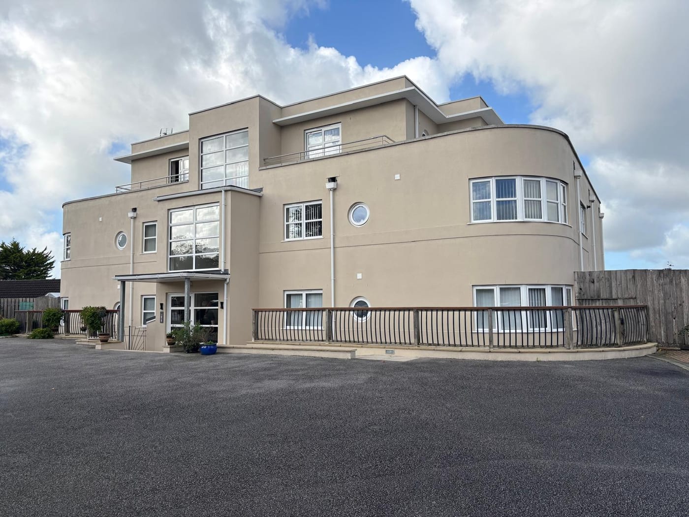
- Rialto Court, an Art Deco style block on Porthpean Road, repainted in summer 2026
- Polmear Apartments, stone-built apartments at Charlestown, on the same estate as Waterwheel Apartments

Insure on the Block's Position, Not the Area's Name
No Environment Agency Flood Zone 2 or 3 falls within 500 metres of the town centre, and the town has no contained Environment Agency flood area. Ten areas lie within eight kilometres, but none covers more than 3.6 per cent of the town. The alert area labelled St Austell and Par Rivers is easily misread. Despite carrying the town's name, its published description names Pentewan, St Blazey, Luxulyan and Mevagissey, and does not name St Austell at all. No Environment Agency area names a single St Austell street. The coastal warning area for the stretch from Lizard Point to Gribbin Head touches 0.3 per cent of the built-up area, and the part it touches is Charlestown rather than the town. For most blocks in the town, insurers should be given the block's actual position rather than an area label that suggests a river risk.
Holy Trinity Is Grade I, and Charlestown Only Half Inside
Two conservation areas fall inside the built-up area. The St Austell conservation area originally covered just the centre and the church and was extended to Fore Street in 1976. It covers 44.4 hectares and is almost wholly inside the town, and its appraisal and management plan were revised in 2013. Charlestown, the Georgian harbour village on the eastern edge, was designated on 31 October 1967, within months of the Civic Amenities Act. It is only 56.3 per cent inside the built-up area and is better described as adjoining the town than as part of it. Pentewan carries its own designation too. Both town areas have published appraisals, and Charlestown's runs to a 15 megabyte document. For a block in either area, the appraisal sets out what external changes are likely to be acceptable, and should be read before works are specified.
38 listed buildings sit within 500 metres of the town centre, one of them Grade I and three Grade II*. 103 entries on the National Heritage List fall inside the built-up area, one Grade I and six Grade II*. The Grade I is Holy Trinity Church, listed in November 1950, inside the St Austell conservation area. Of the six Grade II* entries, four are in the St Austell area and two are at Charlestown, including the harbour itself with its inner dock and quays. One, the Long Stone, is inside the town but outside both conservation areas. Because Charlestown's conservation area is only just over half inside the built-up area, three Grade II entries there sit inside the conservation area but outside the town. A block in a listed building needs listed building consent for works that affect its character, and that consent should be in place before the works are specified.
No Neighbourhood Plan for 81.7 Per Cent of the Town
Decided under the Cornwall Local Plan strategic policies for 2010 to 2030, adopted on 22 November 2016, which replaced most of the saved policies of the former Restormel Local Plan of 2001. The development plan is a set of documents read together, including the site allocations, climate emergency and minerals safeguarding documents and the community network area sections. There is also a St Austell-specific supplementary document on china clay restoration and tipping. St Austell parish covers 81.7 per cent of the built-up area and has no neighbourhood plan at all, neither a made plan nor a designated area. The fringes of the town are covered by several. St Mewan's plan was made on 23 May 2018, and St Austell Bay's on 28 October 2021, covering Charlestown, Duporth and Porthpean. Carlyon's was made on 22 February 2024. Treverbyn has been designated since January 2016 without a plan, and Pentewan Valley reached publication consultation in 2026. The St Austell Bay principal residence policy applies in Charlestown and Duporth only. There, second and holiday homes run at 28 per cent in Charlestown and 32 per cent in Duporth, against under 12 per cent across the rest of the parish. Charlestown also carries a conservation area Article 4(2) direction on householder permitted development rights. Cornwall has published no Article 4 directions to the national register. A block in St Austell town itself is decided on the county local plan alone. One at the edge may also fall under a neighbourhood plan, so the applicable policy should be confirmed before consents are sought.
What Else Changes About Managing a Block in St Austell
- St Austell is the closest of the main Cornish towns to Plymouth, about 40 road miles from Queen Anne's Battery.
- The town centre is about two miles inland of St Austell Bay, so exposure differs markedly between the centre and the Charlestown and Porthpean stock.

Tribunal Decisions on Blocks in St Austell
Published First-tier Tribunal decisions on named developments here, each read in full. They show what the tribunal expects of whoever runs a block in this area.
| Development | Issue | Decided |
|---|---|---|
| Jace Court, Priory Road | Appointment of a manager | 20 January 2025 |
| Jace Court, Priory Road | Service charge | 5 February 2025 |
Going Deeper in St Austell
Towns and Villages We Cover Around St Austell
Charlestown, Carlyon Bay, Par, Pentewan, St Blazey.
Service charge or accounts query? Email accounts@
St Austell Questions
Does the St Austell Bay Principal Residence Policy Affect a Block in Town?
Not in the town itself. The St Austell Bay plan, made in October 2021, covers Charlestown, Duporth and Porthpean. Its principal residence policy applies in Charlestown and Duporth only. There, second and holiday homes run at 28 and 32 per cent, against under 12 per cent across the rest of the parish. A block in St Austell town is decided on the Cornwall Local Plan alone.
Can We Read the Conservation Area Appraisal for the Town Centre?
Yes. Cornwall Council publishes the St Austell appraisal and management plan, revised in 2013. The conservation area covers 44.4 hectares, almost wholly inside the town, and was extended to Fore Street in 1976. Charlestown has its own published appraisal.
How Mixed Is the Flat Stock Across the Town?
Very. Across 10,768 households in the built-up area, 13.5 per cent are in purpose-built blocks against 8.3 per cent for Cornwall. The St Austell Central and Gover division is 23.5 per cent purpose-built flats and was 33.3 per cent flats in total at the 2021 Census. Bethel and Holmbush is 4.9 per cent purpose-built flats.
Nearby Areas
Talk to Us About Your Building in St Austell.
A free, no-obligation proposal, written so it can be circulated to a board.